Our friend, Angela, had recommended a drive around the "Enchanted Circle" in the northern part of New Mexico. On Saturday, we decided to make the drive. Here is information I found at
http://enchantedcircle.org/page.php?p=about:
New Mexico has long been known as The Land of Enchantment, and it’s only
fitting that this designated scenic byway be called the Enchanted
Circle. Explore the 83-mile loop through mountains, valleys, mesa, and
national forest… all unique to Northern New Mexico. The Enchanted
Circle is centered around Wheeler Peak, the highest point in the state.
Culture and outdoor recreation are abundant around the Enchanted
Circle, so hit the road and get ready to discover what makes this region
so spectacular.
 |
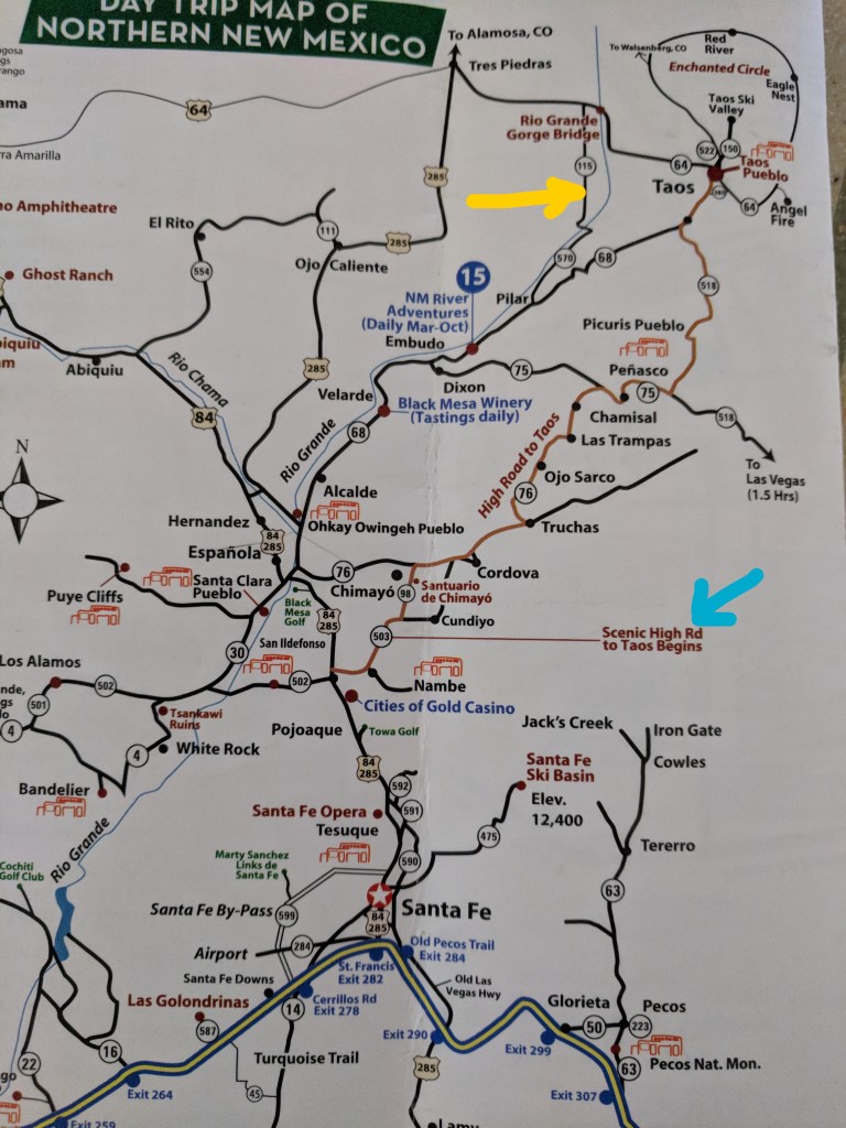
| Map of the area from the brochure we got at the Santa Fe Visitor's Center - we decided to take the "Scenic High Road to Taos", proceed around the Enchanted Circle counter-clockwise, and end by seeing the Rio Grande Gorge Bridge. Because we would take Route 64 to the bridge, we decided we would take the smaller road back to route 68 (the "Low" road from Taos to Santa Fe). |
 |
| There wasn't about a destination, but rather the journey... so we stopped when we saw interesting things! This rock formation alongside the road was just neat! |
 |
| A scenic stop in high desert ... |
 |
| And then we were in mountain forests! |
 |
| So beautiful! |
 |
| We stopped in Angel Fire. I tried (unsuccessfully) to find something that indicated the topography of this town - it was a broad valley after coming through very narrow valleys - high elevation, but very few trees in the valley. |
From the website:
Following the death of their son, U.S. Marine Corps First Lieutenant
Victor David Westphall III, Jeanne and Dr. Victor Westphall began
construction of the Vietnam Veterans Peace and Brotherhood Chapel to
honor the memory of their son and the fifteen men that died with him near Con Thien, South Vietnam on May 22, 1968.
David's mother, Jeanne Westphall, suggested that the
money from David's life insurance policies be used to create the
"Vietnam Veterans Peace and Brotherhood Chapel." She and David's father,
Dr. Victor Westphall dedicated the rest of their lives to seeing this
vision become a reality.
Building a memorial to honor Vietnam veterans was
not popular during this time; the country was still involved in an
increasingly unpopular war in Vietnam. However, the Westphall family
persevered, relying primarily on its own financial resources.
The Chapel was dedicated on May 22, 1971, the 3rd
anniversary of the death of 1st Lt. David Westphall. It was the first
major memorial created to honor the veterans of the Vietnam War, and
inspired the establishment of the Vietnam Veterans Memorial in
Washington D.C., which was completed over ten years later, in 1982.
 |
| The auditorium and chapel |
 |
| From the brochure that I picked up on site: "Viking Surprise, UH-1D 64-13670. This helicopter served with the 121st Assault Helicopter Company (AHC) as a smoke ship and earned the name 'Viking Surprise'. It was badly damaged on Easter Sunday, 1967, while assisting a rescue operation in the Mekong Delta region. The Viking Surprise was rebuilt on the USNS Corpus Christi where an inspection revealed it had been riddled with 135 bullet holes. After it was repaired, the Viking Surprise returned to combat, and later came back to the US where it was put into storage until 1976. Eventually it was acquired by the New Mexico National Guard. In 1999, the Guard donated the Viking Surprise to the Memorial. From October 2016 through May 2017, the Viking Surprise underwent a much needed restoration. Current and retired Guardsmen maintain it to this day." |
 |
| From the brochure: "The Peace and Brotherhood Chapel. In the 1960's, Victor Westphall (Doc) and his wife, Jeanne, purchased 800 acres of the Val Verde ranch with the intention of building a resort. On May 22, 1968, their eldest son, Lt. David Westphall III, was killed in action in Con Thien, Vietnam. Jeanne suggested building a chapel on the site to honor his service and sacrifice. In September 1968, construction of the Peace and Brotherhood Chapel began. Over the years, all but 5 acres of the ranch were sold to finance the project. The Chapel was completed in May, 1971, and was one of the first memorials in the US dedicated to Vietnam Veterans." |
 |
| Inside the chapel - it is narrow and triangular in shape, with one tall narrow window at the front. |
 |
| The round domed area is the "Flag Retirement Area. Every year on Flag Day in June, hundreds of American flags are 'retired' in this area. Flags are honored and ceremoniously burned, and the ashes are covered with an American flag and buried on the Memorial grounds." (from the brochure). Just beyond the round dome is a fenced in area where Doc and Jeanne Westphall are buried. |
 |
| Looking toward the chapel from the area where Doc and Jeanne are buried. |
 |
| There were flags all along the driveway into the memorial, as well as in the town of Angel Fire. |
 |
| Soon after we left the Memorial it suddenly got very hazy and we could smell smoke. |
 |
| When we stopped for lunch, I looked up information about New Mexico fires and found that the roads that were east of where we were were closed due to an active forest fire. We had been on Route 64 and turned onto route 38, so we were not impacted. We read that a number of out buildings at Philmont Scout Ranch, which is south of Cimarron, NM, have burned over the past day. (https://nmfireinfo.com/2018/06/02/ute-park-fire-june-2-2017-morning-update/) |
 |
| Near the northernmost reach of our drive, we crossed the highest elevation of our trip, at 9820'. |
 |
| The northernmost town we reached was Red River, NM - there was a pedal cart in the middle of the road as we came into town - it had 4 folks on it - looked like parents doing the pedaling and 2 kiddos in the front. I was thinking that they should be using the energy of the youngsters for the transportation! |
 |
| Such a pretty town... |
 |
| Still a tiny bit of icy snow on the ski slope above town! |
 |
| There was a classic car rally going on today. We heard the loudspeaker when we came out of the restaurant after lunch so walked over to see what was going on. We didn't pay to go in and see it in any detail, though. They seemed to have representatives from many classic car clubs from this area. |
 |
| Some of the housing areas on the street just off the main road through town. |
 |
| It was plenty high! |
 |
| The Rio Grande isn't quite so "grande" at this point in its flow... |
 |
| Looking east across the bridge. |
 |
| Looking north, up-river |
 |
| Dwayne took the picture of a couple who asked him, and then they offered to take his picture! |
 |
| looking south, down-river |
 |
| We had parked on the east side of the bridge, but while walking across
it, we noticed that there was a rest area on the west side and that we
could get pictures from there, so Dwayne walked to the rest area while I
went back and got the Jeep to drive there. The Jeep (with me driving) is about halfway across in this picture. This picture allows you to
see the span. |
The Garmin wanted us to take US 64 back to Taos, but we'd already driven that, so we decided to take the road that I marked with the yellow arrow on that map up at the top of this post...
 |
| We knew it was going to be a switchback road... we didn't know it was gravel! |
 |
| But, it was beautiful! |
 |
| Eventually we came to another bridge... |
 |
| ...on which we again crossed the Rio Grande - not as high or long a bridge! |
 |
| It was a bit more "grande" at this point - wider at least - with folks
rafting, fishing, and canoeing in the river. |
We thoroughly enjoyed our day, driving about 250 miles, seeing all sorts of beautiful scenery, and appreciating God's creation!


No comments:
Post a Comment