 |
| One of the things at the center that was interesting and fun for children and adults alike were, what I would call, "sight and sound" theaters. This picture is of one of those, experiencing a river crossing in a covered wagon - the video was showing at the front, the passengers (visitors to the center) were seated on boxes and barrel in the wagon, and the wagon lurched and bumped across the river with the video being shown. |
 |
| This gives you an idea of the Oregon Trail from Independence, Missouri to Oregon City. The emigrants traversing this trail were primarily farming families lured by promises of rich soil and free land who made the 4-6 month 2000 mile trek. |
 |
| From east to west: Independence, Missouri: Emigrants stocked up on supplies and gathered information at this and other "jumping off" towns along the Missouri River. Fort Kearney: Near Fort Kearney, the trail from Independence first joined the Platte, the river that would lead the emigrants to the Casper area. |
 |
| From east to west: Fort Laramie: This fort opened in 1814 as a private trading post, where emigrants could find useful supplies and a blacksmith. It was a U.S. Army installation by 1849. Red Buttes: Tall buttes forced emigrants to cross and leave the North Platte. Parties took on water for their first grueling stretch away from a river. Independence Rock: Groups reached the Sweetwater River at this point. They were on schedule if they arrived by the Fourth of July. Devil's Gate was just ahead. Fort Bridger: Jim Bridger and Louis Vasquez built this trading post to do business with emigrants. Previous forts and trading posts had served the fur trade. South Pass: This pass through the Rockies was the key that unlocked the West to overland emigration. It offered a gentle grade for wagons and livestock. Fort Hall: This rough outpost marked the start of the last leg of the journey - through difficult, rocky land along the Snake and Columbia rivers. |
 | |||||
| Oregon City: Oregon City marks the end of the Oregon Trail. Emigrants fanned out from here to settle throughout the Willamette Valley and beyond. |
 |
| The Mormon Trail from Nauvoo, Illinois to Salt Lake City, Utah. The Mormon Trail was seeking freedom from religious persecution. |
 |
| From east to west: Nauvoo, Illinois: Nauvoo was the last home of the Mormon Church before the migration to the Salt Lake Valley. Winter Quarters: The Mormons established this camp on the west bank of the Missouri River in 1846. It was a staging area for the trek west until 1848. |
 |
| From east to west: Fort Laramie: Most Mormons traveled the Platte's north side opposite the Oregon and California trails. Here, they crossed to the south and joined the other groups. Mormon Ferry: The difficult North Platte River crossing inspired the Pioneer Party to establish a ferry. It helped later Mormons and, for a fee, other emigrants. Martin's Cove: After enduring a severe blizzard, the Martin Handcart Company took shelter at Martin's Cove while awaiting rescue.Rocky Ridge: Emigrants traveled over Rocky Ridge -- a series of hills capped by rocks -- to avoid the canyon formed by Sweetwater River. Fort Bridger: Established in 1843, this station served the Oregon, Mormon, and California Migrations. Mormons bought the fort in 1855 to supply emigrant parties. Salt Lake City: Brigham Young chose the isolated Salt Lake Valley for its plentiful water and fertile valleys as the final destination of the Mormons. |
 |
| The California Trail was primarily traversed by men pursuing gold. |
 |
| From East to West: Council Bluffs Road: Travel along this trail on the north side of the Platte was basically ths same as the more popular southern route. Less traffic meant less cholera. Cherokee Trail: Cherokee Indians pioneered this trail to the California gold fields in 1849 and 1850. Portions of it became the 1862 Overland Stage Route. |
 |
| From East to West: Sublette Cutoff: This bypass saved seventy-five miles but meant crossing a fifty-mile stretch of waterless desert. Eighty percent of gold miners used it in 1849. Hensley Cutoff: This popular route was shorter than going via Fort Hall, safer than Hastings Cutoff, and more convenient to resupply at Salt Lake City. Hastings Cutoff: This difficult trail through the salt flats contributed to the 1846 Donner Party tragedy.Hudspeth Cutoff: Mapped in 1849, this cutoff was rumored to save up to fifty miles. Actually only ten miles shorter, it had a stretch of desert and more hard climbs. |
 |
| Sailing to California: Some gold rushers sailed to Central
America, walked aross the Isthmus of Panama, and took another boat to
California. Others sailed around South America. Sutter's Mill: The discovery of gold at Sutter's Mill on January 24, 1848 sparked the Gold Rush the next year. |
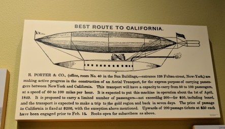 |
| If only! http://www.flyingmachines.org/prtr.html |
 |
| The Pony Express Route. |
 |
| St. Joseph, Missouri: St. Joseph was chosen as the eastern end of the Pony Express. It was a large town on the Missouri River where the railroad and telegraph from the East ended. |
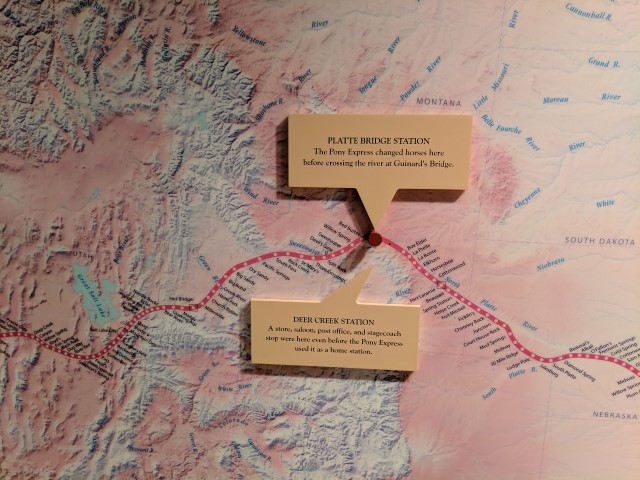 |
| Deer Creek Station: A store, saloon, post office, and stagecoach stop
were here even before the Pony Express used it as a home station. Platte Bridge Station: The Pony Express changed horses here before crossing the river at Guinard's Bridge. |
 |
| Sacramento, California: Sacramento marked the western end of the Pony Express route. |
 |
| Anyone want to sign up??? |
 |
| A view over Casper to Mount Casper from the Trails Center... we decided to drive across town and up Mount Casper. |
 |
| We stopped at an overlook on our way up the mountain... |
 |
| We could barely see some Bluebirds at the fairgrounds from there (with super zoom on the camera or the binoculars). |
 |
| We continued following the Garmin's directions to "Mount Casper" and eventually found ourselves at the communication towers at the top on a VERY rough road! |
No comments:
Post a Comment